Article details
- Posted by: Aitor Castro
- Tags: air speed, course, bearing, meteo wind
- Difficulty: Basic
- Updated: September 12, 2018
- Title: Meteo wind estimation
- Description: Meteo wind estimation
- Skills: Physics, geometry
One of the main features of today glide computers is the estimation of wind, the speed and direction of the air mass we’re moving in. It’s the base of other glide insturment estimations like the required time and altitude to reach a waypoint.
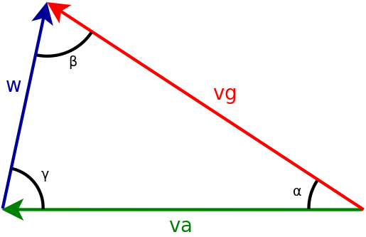
A vectorial magnitude consists of direction and strength. One example of a vectorial quantity is the wind. We can graphically represent a vectorial magnitude with an arrow. The direction is where the arrow points to, and the strength is represented by its length.
-
The blue arrow in the graph above represents the wind.
-
The green arrow represents the speed of our glider with respect to to the airmass we are flying in. It’s also a vectorial magnitude whose strength, measured by an anemometer, is the air speed (TAS) and whose direction, measured with a compass, is the course. The course is the heading of our glider, the direction in which our glider’s nose is pointing.
-
The speed over de ground (red arrow) is the sum of this two vectorial magnitudes. The speed over the ground is also a vectorial magnitude whose direction is the bearing or the flight direction of our glider. We can measure the strength and direction of ground speed with a gps.
To obtain the wind we should vectorially substract the air speed from the ground speed \(\color{black} \vec{w} = \vec{v_g} - \vec{v_a} \) but the vast majority of glide instruments don’t have an anemometer to measure the airspeed. How do they manage to estimate the wind? In fact, they don’t estimate the instant wind but rather the meteo wind. The wind that remains after removing the convective air gusts. They assume that the modulus of the airspeed, though unknown, is constant too. Making this two assumptions and taking the ground speed measured by the gps in at least three different moments we can pose a resolvable system of equations whose solution is the meteo wind.
$$\color{black} \vec{w} = \vec{v_g}^1 - \vec{v_a}^1$$ $$\color{black} \vec{w} = \vec{v_g}^2 - \vec{v_a}^2$$ $$\color{black} \vec{w} = \vec{v_g}^3 - \vec{v_a}^3$$
The superindex represent the instant in time. At first glance it would seem a system of three equations with four unknowns with infinitely many solutions. Every vectorial equation can be decomposed into two scalar equations therefore this a system o six equations. Similarly every vectorial unknown is composed of two scalar unknowns (modulus and direction) so we have two unknowns for the modulus and direction of the wind. Three more unknowns that correspond to the direction of the air speed (course) in each different time instant. Remember that we have assumed that the modulus of the air speed is constant so this is the sixth unknown.
We don’t want to bore you with the mathematical calculations but they are roughly similar to derive the geometric 3D plane from three points it passes through. When we add noise to the position of this three points, just as it happens with the gps data, and the points are near, the solution of the system of equations can lead us to a completely different plane. It’s what we call an ill-posed problem. To avoid it we must take more than three points and make sure they are far enough from each other.
In the present case that means taking ground speed samples along a time window sufficiently long and in a wide range of directions of flight. However, if we use a time window too large we won’t record changes in the meteo wind due to variations in the weather conditions or flight zone changes. A time window of 10 min. is small enough to detect meteorological and geographical changes of wind in the scale of 5 km while still providing a reliable estimate.
Nevertheless the wind also changes with altitude, sometimes suddenly when we move from one air layer on to another one. At a climb rate of 2 m/s during 10 min we can climb up 1200 m. This altitude gain is enough for the meteo wind to significantly change. If we use a 10 min. time window this changes will inadvertently pass because they will be averaged.
If you want to know how airspace app resolves all this issues see the article Meteo wind